Parrot Disco Pro AG Technical Specifications
![Parrot Disco Pro AG Drone manual cover](/images/81e5ba594b282370fd357bca/thumbs/thumb175x175.webp)
![English English](/static/img/blank.webp)
A L L - I N - O N E D R O N E S O L U T I O N F O R P R E C I S I O N A G R I C U L T U R E
DISCO-PRO AG Powered by
A N A L Y Z E & D E C I D E N D V I M A P S V I A C L O U D S E R V I C E
S A F E E A S Y T O P I L O T R E T U R N H O M E
P A R R O T S E Q U O I A R G B & M U L T I S P E C T R A L
S E N S O R
M U L T I - P U R P O S E T O O L P H O T O 1 4 M P X
V I D E O 1 0 8 0 P F U L L H D
8 0 h a C O V E R A G E A T 1 2 0 M * F L I G H T
A L T I T U D E ( 2 0 0 A C @ 4 0 0 F T )
N D V I & S M A R T Z O N I N G M A P S
I N C L U D E S O N E Y E A R S U B S C R I P T I O N
T O C L O U D S E R V I C E
OVERVIEW Parrot Disco-Pro Ag is the multi-purpose all-in-one precision agriculture solution for farmers that fits in their everyday tool box to help them improve ROI of their large crops. This end to end multi-purpose solution allows farmers to have easily and quickly insights on their crops whenever they need to: Identify crop health, relative crop maturity and areas damaged thanks to the AIRINOV report based on
NDVI maps Perform a quick overview of the crop and the farming infrastructures with the Parrot Disco-Pro front Full
HD stabilized camera
Thanks to the automated flight of the Parrot Disco-Pro, the Parrot Sequoia multi-spectral sensor captures invisible data of your crop from the sky. Once processed in the easy to use and powerful agriculture mapping cloud platform AIRINOV First +, the AIRINOV report is generated presenting NDVI maps that gives actionable insights on the health of the crop.
F LY No need to be a professional pilot: Fly safe and easily the Parrot Disco-Pro with the Pix4Dcapture navigation app whenever you need to, the Parrot Disco-Pro will automatically fly over the selected area and return to home to land when the fly is finished
C A P T U R E Automatic capture of visible and invisible crop data from the sky thanks to the advanced Parrot Sequoia multi-spectral sensor
P R O C E S S Process your crop data with the powerful and easy to use agriculture mapping cloud solution AIRINOV First +. Analyze your crop health thanks to the actionable AIRINOV report with NDVI maps
Powered by
Crop Scouting Full HD Video camera
Photo 14Mpx
THE MULTI-PURPOSE TOOL FOR THE FARMER Visual Scouting Crop Mapping
Front Camera for visual inspection of crops, farm infrastructure and livestock
Camera modes:
Video: Full HD 1080p Photo: 14Mpx
Parrot Sequoia for crop mapping from the sky and creation of NDVI maps
Features:
4 sensors to capture different wavelengths RGB camera for visible color mapping
Crop Mapping Parrot Sequoia Multispectral sensor
FLY Parrot Disco-Pro is based on the consumer-proven flying wing Parrot Disco: reliable, safe and easy to pilot thanks to its advanced autopilot
Pix4Dcapture is the easy to use flight planning mobile app that creates automatic and optimal flight plans to map a defined area.
A R E A CO V E R A G E : 8 0 H A ( 2 0 0 A C ) P E R B AT T E R Y
AT 1 2 0 M F L I G H T A LT I T U D E ( 4 0 0 F T )
H A N D L AU N C H TA K E O F F
AU TO M AT I C & S A F E L A N D I N G
R A N G E : U P TO 2 K M / 1 . 2 4 M I L E S *
*with Parrot Skycontroller 2 in an interference
free and unobstructed environment
Parrot Sequoia Multispectral sensor
Sunshine Sensor
30min Flight Time
Full HD Video Camera Photo 14Mpx
Air Speed Sensor
C.H.U.C.K Advanced Autopilot
Pix4Dcapture is the easy-to-use flight planning mobile app that creates automatic and optimized flight plans to map a defined area from your mobile device. Easily define flight missions to map areas at the tip of your fingers Customize mapping parameters like flight altitude according to your needs
OPTIMAL FLIGHT PATH
The optimal flight path is automatically computed by the mobile app
to map the defined area.
OPTIMAL DATA CAPTURE
The solution will manage the photo capture from Parrot Sequoia to ensure a proper mapping.
Surface orientation modification
Loiter point after take-off Switch to front camera
video streaming
Surface size modification
Flight Altitude selection
Landing point selection and
approach path
When clicking start a check list will appear, if all the elements are green
a countdown will start for take-off
CAPTURE PA R R OT S E Q U O I A C A P T U R E T H E I N V I S I B L E
The Parrot Sequoia multispectral sensor captures automatically both visible and invisible images, providing advanced data to optimally monitor the health and vigor of your crops. In addition to the visible images, Parrot Sequoia captures wavelength, Green, Red, Red-Edge and Near Infrared to highlight the health of plants.
A synchronous, global shutter drone sensor with four different bands and an RGB camera
for visual scouting.
A fully-integrated sunshine sensor captures and logs the current lighting conditions
41 mm
28 m
m
59 m m
Red Wavelength 660nm Bandwidth 40 nm Definition : 1.2 Mpx
Green Wavelength 550nm Bandwidth 40 nm Definition : 1.2 Mpx
Red edge Wavelength 735nm Bandwidth 10 nm Definition : 1.2 Mpx
Near infrared Wavelength 790nm Bandwidth 40 nm Definition : 1.2 Mpx
Lens protector strong and durable
RGB camera : Definition : 16.0 MpxInternal storage
64 GB Easy and fast access via Wi-Fi and USB
47 m
m
18 .5
m m
39.6 mm
GPS & IMU Precise geo-tagging technology
Additional storage thanks to SD card slot
The multispectral sensor 72 g / 2.5 oz The sunshine sensor 36 g / 1.3 oz
The health of plants can be identified according to how they reflect light in the different wavelengths
Green Vegetation Reflectance
Photosynthesys
Signal correction
Reectance
VE R
T
R O
U G
E
R ED
E D
G E
PI R
G R
EE N
R ED
R ED
ED G
E
N IR
Concept
Visible light
R e
ec ta
nc e
(% )
Wavelength (nm)
Healthy Plant Stressed Plant Soil
0,7
0,6
0,5
0,4
0,3
0,2
0,1
0 400 500 600 700 800 900
G re
en
R ed N
IR
R ed
ed g
e
PROCESS AIRINOV First+ is the powerful and easy to use agriculture mapping cloud solution dedicated to Parrot Disco-Pro AG.
AIRINOV First+ automatically processes the crop data captured by the Parrot Sequoia sensor and generates an actionable report.
The AIRINOV report can be analyzed to identify intra-field variability: Crop health Relative crop maturity Problem areas in a crop field
Key features: 1 year subscription to the AIRINOV First+ cloud service Easy to use and quick generation of the AIRINOV report sent directly to your email address Up to 150ha (370ac) per week
Get insights with the AIRINOV report in 3 simple steps
Create your account on Parrot.airinov.com
Upload the crop data on the AIRINOV First+
cloud platform
Get your AIRINOV report directly on your email accpunt
and analyze your crop
NDVI map, the easiest way to measure
intra-field variability
Simple zoning map for
quick analysis
Detailed zoning map to help do Variable
Rate Application
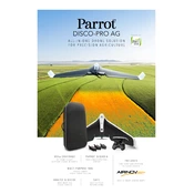
PA R R OT D I S CO - P R O
PA R R OT S E Q U O I A
OPERATION OVERVIEW
Area Coverage: 80ha (200ac) in a single flight at 120m flight altitude (400ft)
Ground resolution: 14.8cm/px (5.5in/px) at 120m (400ft) flight altitude
Automatic flight plan powered by Pix4Dcapture app
Hand launch for take-off Automatic landing
GENERAL
Weight : 780 g without Parrot Sequoia
Take-off weight : 940 g with Parrot Sequoia & mounts
Size : 1150x580x120mm (45x22x5in) Wingspan : 1150 mm (45 in) Removable wings for transport
PHOTO & VIDEO
Photo: 14Mpx wide angle camera Video: 1080p Full HD Video streaming : 480p / 720p Internal Memory: 32GB
RGB CAMERA :
Resolution: 16 Mpx, 4608x3456 pixels
HFOV: 63.9
VFOV: 50.1
DFOV: 73.5
4 GLOBAL SHUTTER SINGLE-BAND CAMERAS :
Resolution: 1.2 Mpx, 1280x960 pixels
HFOV: 61.9
VFOV: 48.5
DFOV: 73.7
4 SEPARATE BANDS :
Green (550nm BP 40nm)
Red (660nm BP 40nm)
Red Edge (735nm BP 10nm)
Near infrared (790nm BP 40nm)
WI-FI AND TRANSMISSIONS
Range: Up to 2km with Parrot Skycontroller 2, in an unobstructed area free of interferences
WiFi AC-type, 2 bi-band antennas (2,4 and 5GHz)
REMOVABLE BATTERY
Battery life : 30min with Parrot Sequoia 2700 mAh / 25A 3 cells Lipo Battery
SENSORS
Airspeed sensor (Pitot tube) Built-in GPS + GLONASS Inertial Navigation System Altimeter Ultrasound Optical flow camera
GENERAL CHARATERISTICS : Dimensions: 59x41x 28mm (2.3x1.6x1.1in) Weight: 72 g (2.5 oz) Photo mode: Up to 1 fps Internal storage: 64 GB built-in storage Inertial measurement unit & magnetometer Power: 5 W (~12 W peak)
SUNSHINE SENSOR (INCL. IN PARROT SEQUOIA) : Dimensions: 47x39.6x18.5mm (1.8x1.5x0.7in) Weight: 35 g (1.2 oz) 4 spectral sensors (same filters as body) GPS Inertial measurement unit & magnetometer SD Card slot Power: 1 W
TECHNICAL SPECIFICATIONS
*Always check local legislation to comply with applicable regulations. Pix4D, Pix4Dcapture are trademarks or registrered trademarks of Pix4D SA, used under under license thereform. AIRINOV, AIRINOV FIRST + and AIRINOV logos are trademarks or registered trademarks of AIRINOV SAS. Parrot and Parrot logo are trademarks or registered trademarks of Parrot SA, used under license therefrom. Parrot Disco Pro, Parrot Skycontroller and Sequoia are trademarks or registered trademarks of Parrot Drones SAS.All other trademarks are the property of their respective owners. App Store is a service mark of Apple Inc. Google Play and the Google Play logo are trademarks of Google Inc. Parrot